

Day 4 – August 3
Paradise River to Devil’s Dream // 11.1 miles
I woke up early and did 3 easy miles downhill to Longmire. I picked up my food cache and connected to the visitor WiFi. The Wifi was good enough for me to make a call to my boyfriend, Adam. It was really nice to hear his voice. He seemed happy to hear from me, too. He told me he’s proud of me and is excited to meet up with me in a few days.
After picking up my food cache from the Wilderness Information Center, I got a breakfast burrito from the inn and had breakfast with some of the people who were at Paradise River with me last night. We sorted through our cache as we ate and traded chocolates and coffee. I’m really happy to be meeting other hikers and be a part of this amazing community.

The mountain above the Nisqually River
I was about a half mile out of Longmire when I realized all of the podcast episodes I downloaded on my phone on Spotify had disappeared. I freaked out because my podcasts help me sleep at night by keeping my mind off the random forest noises. I basically sprinted back to Longmire so I could re-connect to the Wifi and try to re-download my episodes. Once I got onto the WiFi, my podcasts came back, which was a huge relief. I think that added about a mile to my day overall, but it was worth it to me.

The glacial rivers shape the valleys they run through
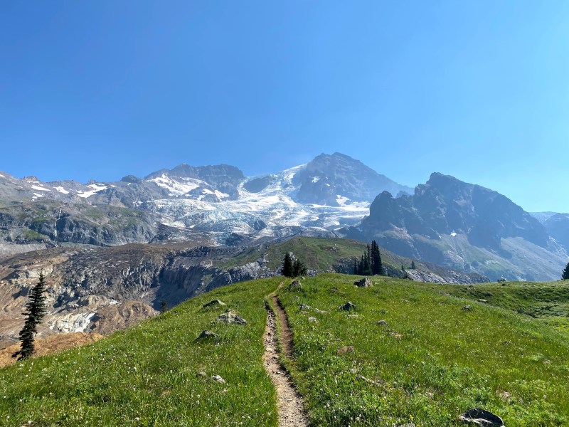
Most of my day was in the peaceful forest. It was nice to be in the cool shade while I was climbing. I crossed a few glacial rivers: Kautz Creek and Pearl Creek. Pearl Creek especially was flowing really fast. These two rivers are so powerful and unpredictable that they consistently wash out the trail on either river bank. Thankfully, the park builds cairns to help hikers navigate through these areas.
The final push to Devils Dream was a little long, but not as bad as the climb out of Stevens Canyon. That was terrible. So far that climb and the descent into Indian Bar have been the worst parts of the trail for me.

The mountain above Pearl Creek
I got to camp around 2pm, set up my tent, and took a 40 minute nap. This camp is big, as it has 7 individual sites and a group site. I think all the sites are full tonight. I’m in number 3, which has a direct line of sight to number 2 which is why I picked it. It helps me feel less alone if I can easily see another tent from mine.
I had dinner with three guys in their late 60s that have also camped at Summerland and Paradise River the same nights as me. They have some great stories. I hope I’m as cool as they are when I’m in my late 60s. This camp is notorious for bugs, but with long clothing and a head net, they are manageable.

My tent at Devil’s Dream
I am nervous for tomorrow. I have 4100 feet of elevation gain and 5400 feet of loss over 13 miles. I’m just telling myself to break it into chunks and just focus on one chunk at a time.
Day 5 – August 4
Devil’s Dream to North Puyallup River // 13.8 miles
I was really nervous about today but it ended up being my best day on trail so far. My plan was to sleep in a bit this morning but I woke up at 5:30am cause everyone else at camp was waking up and being loud. I decided to get up and go too since I was already awake.

Indian Henry’s Hunting Ground
First, I went through Indian Henry’s hunting ground which had a nice meadow with a lot of wildflowers. There’s also a patrol cabin that is one of the oldest in the park, but I didn’t stop to look. The west face of Rainier looms above.
Next, I descended to Tahoma Creek which has a suspension bridge. It’s pretty high off the river and very cool. It was a bit shaky to walk across though. After that, I started my first of two big climbs: the climb up to Emerald Ridge. I decided to hike a little slower than I normally do while hiking uphill and found that I didn’t need to take as many breaks. It was probably faster overall and much less exhausting.

Suspension Bridge over Tahoma Creek
Emerald Ridge is completely amazing! There are great views of the west face of Rainier and the Tahoma Glacier. I haven’t seen this side of the mountain much, so I took a ton of photos. At the top of Emerald Ridge, I had breakfast and sat with the three older guys I had dinner with last night. I like getting a few miles in before breakfast. It’s a nice way to break up the day.
View from Emerald Ridge
After that, we descended into the South Puyallup River valley. It was nice to hike with other people after hiking alone for two days. We filled up our water at the bottom of the valley, before beginning the final climb up to Klapatche Park. We stopped for a lunch break in the middle so it wasn’t too bad. The top of the ridge was amazing. There were views in all directions and so many wildflowers. It really did feel like a wonderland.
I parted ways with the guys at St. Andrews Lake. They were staying at Klapatche Park, which is only a half mile from the lake, so they planned to go for a swim. I just wanted to get a little more water and soak my feet for a few minutes. I wish I could have stayed longer because it was so beautiful and the water was warm. It would have been nice to go for a real swim.

St. Andrews Lake
As I was heading down to the lakeshore, I ran into a ranger who checked my permit. He also told me the bridge is in at South Mowich River which is a big relief. It is still out when I left a few days ago and I’ve been really nervous about trying to ford it alone.
After relaxing by the lake for a few minutes, I began the massive descent into the North Puyallup River valley. The descent was really long. It had lots of switchbacks and was kinda rocky. For the first time all trip, my feet began to hurt and I began stumbling and tripping more often. I tried to pay attention but I was getting so tired. Finally, I arrived at camp. I got to the group site first but then had to cross the river to get to the individual sites.

Wildflowers near Klapatche Park
I tried to set up my tent but the ground was too rocky for me to get stakes in. I got frustrated so I ate a little food to calm down. After that, I decided to pitch my tent using the “little rock, big rock method,” which involves using rocks to hold down the corners of my tent. All things considered, my tent pitch is pretty good.
I’m excited to see Adam tomorrow. I miss him a lot and it will be nice to have someone in my group again. I definitely do enjoy solo hiking and camping. There is a lot of freedom in it. I can get up when I want, stop when I want, and hike at my own pace. But, it is also amazing to share such adventures with loved ones and know they are looking out for you.
Day 6 – August 5
North Puyallup River to South Mowich River // 11.8 miles
Today has probably been one of the hardest days on trail. I woke up and left camp around 6:30 am to begin the climb to Golden Lakes. Not long after I started, a father/daughter pair came up behind me. I hiked and chatted with them for a while. This is their third time hiking the trail!

Mt. Rainier through a hazy sky
Eventually I fell behind them on the climb because they were moving so fast. As I came to the top of the ridge, I hiked through an area that had been burned by a wildfire in the 1930s. I also got my first and only view of Rainier for the day. The sky was so hazy that the sun looked red above the mountain. Soon after, I ran into the father/daughter pair who stopped to eat some huckleberries they found on trail. I ate a few handfuls as well. They were delicious and refreshing.

Patrol Cabin at Golden Lakes
I stopped for breakfast a short while later at Golden Lakes. I also kinda had a small breakdown. I’m starting to get physically worn out and I’m tired of being dirty and sweaty and constantly fighting bugs. I’m so ready for a shower. I felt a little better after I ate and decided to put on a podcast for my final 6 mile descent to South Mowich River.
All in all the descent was pretty good. About 2.5 miles north of Golden Lakes, I came across a massive blowdown. It looked like 4 big trees had fallen on the trail. There were actually several blowdowns I navigated today, but this was the biggest. I had to climb over the downed logs to find the trail again.

Amazing reflection at Golden Lakes
My feet started hurting at the end of the day, but I finally made it to the South Mowich River valley. The bridge is indeed in, so I was able to safely cross the river. A short while later, I came across camp. There are supposed to be 4 individual sites and a group site. I could only find sites 1, 4, and the group site. Site 3 had a bunch of downed trees in it and I couldn’t even find site 2. It does look like there are some unmarked sites though. I set up in site 4 and had lunch.

South Mowich River crossing
After I set up the tent I had another breakdown. This trail is hard. I’ve hiked over 11 miles every day except the first one. Tomorrow is supposed to be 11 miles and Saturday will be 12 miles. I’m tired of being alone out here. Even though I’ve hiked with people and hung out with people at camp, it’s not the same as having someone in your group. I also think I’m struggling because I mostly hiked in a forest today. It was kinda boring without any views or exciting parts.

View of South Mowich River from camp
After I had lunch, I took a nice nap in the tent and woke up feeling much better. Adam and his brother, Luke, got here around 5pm. I was so happy to see Adam. I instantly felt better with him by my side.
Shortly after that, another woman arrived at camp and set up near us. I went over to talk to her. She’s hiking alone so I invited her to join us for dinner. She’s from Colorado but just finished school here in Washington. It was a really nice night hanging out with everyone. I’m a little nervous for tomorrow since it’s a lot of elevation gain through Spray Park.


